Holy Moly!
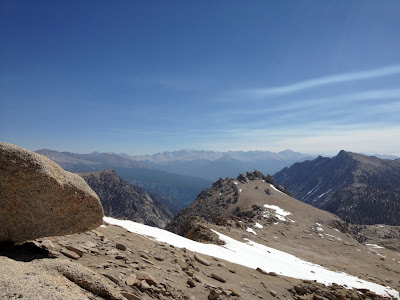
I have found the origin of that beautiful, high definition wallpaper that comes stock on your computer. It is Mineral King Valley in Sequoia National Park.


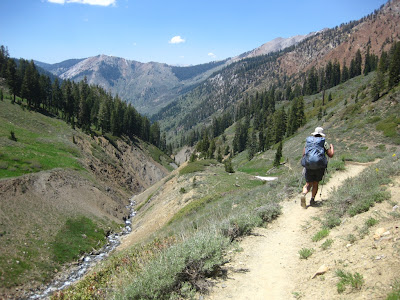
The walk up the road was amazing and we knew we were in for a treat. The weather was surprisingly warm considering there was snow on the mountains.


We reclaimed our gear and headed up the last section of road to the trail head.


Look Ma! Wet feet!


Happy with our wet toes and new creek ford experience, we continue on. The trail is well graded and easy to follow. There are wildflowers everywhere!


Bear Scat!!


You can pick your friends, and you can pick your nose but... well, you get the idea. :-)


We found one more of the three lakes at Franklin Lakes. It was small and stagnant. We continued on to see the frozen lake that we saw from the Pass trail.

It is hard to gauge anything in the place! The areas that look so close are impossibly out of reach and the areas that look far away are only a few miles. Strange place!
This peak is over 12,000 feet, that's at least 3,000 feet from where we stood, but it looked as if you could just run right up!
The frozen lake that seemed so close was impossible to get to. We would cross one boulder field and think we were there, only to find an even larger field laid out in front of us.
Josh and I were hungry and turning into 'divas' like the snickers commercials say, so we started back the way we came.


As the sun started to go down the weather cleared and we thought perhaps we should have kept going. Too late now. We abandoned the frozen lake traverse and headed back toward camp. We stopped to get water and Josh did some Adonis poses for the marmots...in the buff no less. It was awesome!
Sorry, those pix are only for moi. :-)


Every time we passed by this area of trees we heard a low pitched sound akin to the sound you make when you blow into a jug. whooo whooo whooo...
What is it?!
We later asked the ranger who told us it is a male grouse, which is about the size of a chicken.
Further research on the internet shows that grouse are WEIRD BIRDS!
I encourage you all to check them and their trippy mating dance out.


The elusive frozen lake...


Off the General's Hwy, there is a dirt road leading to Dome Rock. It is popular with rock climbers.
We cruised around and surveyed the area. In the distance you could see Mount Whitney.


Silly faces in the rocks make me smile.


Whitney?


Rancher's in the past used to secure their goose flocks in this tree at night to keep them safe from predators.


As we walked the grove we happened upon a Squirrel who was not taking no for an answer. Squirrel rape is quite a sight to behold. Sheesh, no means no dude.


In the middle of the trail there is a downed Sequoia that is so huge it takes your breath away. There is a video on youtube that shows it falling. It was in the middle of the day, without warning. It is frighteningly impressive to see such a huge tree fall. Amazingly, no one was hurt.


The trees start as independent saplings but later grow into each other to increase their chances of survival.

They have such a shallow root system it is amazing they stand so tall!

We finished up our tour and headed out toward Johnsondale and the Kern River.


Is that a stick that chipmunk is sitting on? Or he is really happy to seem me. :-)

After a long and winding road we got to the Johnsondale bridge. I have hiked up the Kern before on this trail and it is beautiful. About three miles up from this bridge is the seven teacups waterfall which is popular with canyoneers.
The river was very, very low for this time of year. I fear we are entering a drought summer.


 Another adventure down. On to the next!
I have found the origin of that beautiful, high definition wallpaper that comes stock on your computer. It is Mineral King Valley in Sequoia National Park.

Sequoia National Forest Adventure!
May 31, 2013 - June 3, 2013
Josh and I took off on Friday for a three day jaunt in the Sierra Nevada. Neither of us had been in an area like this before and we didn't really know what to expect, but we were excited none the less.
We took the 5 north and decided to take the 14 to see where the PCT would take us next year. We passed by Vasquez Rocks, Agua Dulce and Mojave. On our way up we saw the huge plume of smoke caused by the Station Fire. It was impressive.


We wound our way through Tehachapi and made a short detour to see my Dad and Grandma in Bakersfield. My dad didn't answer the door with his gun, as promised, for his first introduction to Josh, so already we were off to a good start.


After a short visit with some of the fam, we drove the rest of the way through the sticks and farms to Mineral King Road which is not for the faint of heart, let me tell you. It was about an hour drive on this one lane unmaintained road.

When we got to the kiosk to pay the State Park entrance fee, Josh said he felt like something cool was about to happen, like we were going to see a bear. Sure enough, we rounded a corner and there was a medium sized black bear attempting to get into the trash cans. He ran up into the ravine but turned around a few times to see if were were going to feed him.


We continued on and watched the terrain change from high desert to mountains. We rounded another corner and saw one more bear taking off down the road. Josh looks at me and says, "is this safe?!" To which I reply, "safe enough I guess, that's why were carrying the bear can." but I was a bit nervous too. That's two bears before we even hit the trail head.

We rounded the corner into the Cold Stream campground at 7500 feet where we would spend our first night. Our jaws dropped at the views of the high pointed mountains and craggy passes, not to mention all the water! Water and waterfalls EVERYWHERE!


We cruised around the campground and found a site that suited us. As I went to get the payment envelope, a marmot ran full speed toward me! I yelled to Josh, who was stoked to see the animal whom supposedly wreaks havoc on hikers cars and gear that we have heard so much about. Apparently, marmots have a tendency to climb up into people engines and chew on the wires and hoses. They also seem to have an affinity for antifreeze. They are very curious little creatures.


We did some reading about food storage and the like in the sierra, as it was all new to us. We put our gear in the metal bear locker provided and took off to explore the area.


Just a bit out of camp were some walk up sites and the trailhead to Targap trail. We were amused by the shoe cleaner thingy at the trailhead. At the end of our trip we realized that it was a welcomed device after tromping through creeks and mud.


We walked up the creek and checked out the foliage and a beautiful waterfall. Had it not been for the bugs, our jaws would have been perpetually dropped.


We went back to camp and Josh made a fire. We had a dinner of summer sausage and chex mix and looked at the mountains and stars with my binoculars before jumping in the truck and calling it a night.


We woke up around 5:45am and started the day with coffee and breakfast.


We packed up our gear and bagged up any item that had a smell, so we could store it at the ranger station to keep bears and marmots away from the truck while we were gone.
I broke my sunglasses and was happy I had a spare pair in the truck. I later dropped that pair in a fast moving creek. Altrighty then, no sunglasses for moi.
Around 8:30am we got our permit from the ranger and learned that there was a lot of snow at Sawtooth Pass which was to be our exit point on our loop. We thought we may need to change our itinerary depending on the conditions we encountered on the way, but were willing to play it by ear. The ranger recommended that we park at the ranger station which is a mile away from the trail head as the marmots were less aggressive with hikers cars in that parking lot.


We drove the road to the trail head and put our gear in the bear boxes there, then we drove back down to the ranger station to park and walk the mile up to the trail head. As we drove away we saw someones creative attempt at keeping the marmots at bay. I wonder if it worked. Other folks leave the hoods of their cars open to dissuade the marmots who like dark places.

The walk up the road was amazing and we knew we were in for a treat. The weather was surprisingly warm considering there was snow on the mountains.


We reclaimed our gear and headed up the last section of road to the trail head.


We hiked up toward Farwell Gap. There were marmots and animals and waterfalls EVERYWHERE!


A mile or so in we came across our first creek crossing. I was admittedly a little surprised by it. In my So. Cal. mountains, creek crossings are very rare and therefore a highlighted point in the description of the hike, as are waterfalls. Not so in the Sierra as there is so many creeks, streams and waterfalls, it is a non issue.


Look Ma! Wet feet!


We arrived at a large open meadow just below Farewell Gap. We pulled up a rock for a snack break and to fill up our water from a nearby creek. When Josh approached the creek he was amazed to see such a large flow disappear under the rocks! While we relaxed in the meadow Josh looked around and remarked how much it looked like a scene from The Sound Of Music. It was then named The Sound of Music Meadow for the rest of the trip.


We continued on to the junction at Farewell Gap and headed toward Rainbow Peak. It is not hard to figure out how it got its name! The mineral deposits and rock formation was amazing.
We traversed another couple of creek crossings which helped us get over our fear of wet feet. We no longer rock and log hoped over the creeks, we just plowed on through.


That is quite a drop. These are the trails my Mom and Dad would worry about me on. Don't look Mom and Dad!!


We started our ascent up the canyon that leads to Franklin Lake and the terrain changed notably from grassy meadows to alpine.


Finally the dam came into view. The wind picked up and it was cold against our sweat laden shirts. We dropped our packs and jumped up onto the dam wall. We found a beautiful snake that had been crushed with a rock, obviously intentionally. That was kind of a bummer. We had leap frogged a couple of kids on the way up that were now laying down in the middle of the dam. We watched as they dropped their water bottle into the lake. It was all I could do not to kick their butts in after it.
What is wrong with people?!


We sat behind the dam for a while, which shielded us from the wind and ate snacks while forming a plan about our next course of action. There were bear boxes at this camp site, which was appealing, but it would mean a huge mileage day tomorrow if we stayed here.
We were also concerned about the snow on Sawtooth Pass, as the snow we encountered on the way up was more like ice. If Sawtooth Pass were to live up to its name we knew it was going to be steep and scary and the ice would only make that worse.
It had only taken us a few miles to realize that these were big-boy mountains and we needed to plan well or we could pay the price later.


You can pick your friends, and you can pick your nose but... well, you get the idea. :-)

We flipped a coin (a dime of course) and its result said we should head on. We took off up the trail towards Franklin Pass. I could not, for the life of me, find where the trail went or where the pass was while looking up from below. It looked like a solid wall of rock.
We took a few switchbacks up and surveyed the weather. It was getting dark fast with cloud cover and cold. Really cold. Clouds like that in So. Cal. mean rain.
I over ruled the dime and suggested we head back down and camp at the lake.


We set up camp over looking the lake and ate some lunch. Shortly after we took off to explore the area. There was a frozen lake we spotted form high up on the switch backs that we wanted to check out as well as the beach that was crawling with marmots. Josh is in love with the marmots by now and wants to take one home.
I, however am not so sure...


We made it around the lake to a large boulder field partially covered in snow. A large portion of the snow patches were pink! This is called Watermelon snow, and is caused by a bacteria that grows as the snow melts, giving it a pink color and a sweet odor. It is best to avoid these patches, as it will stain your clothes pink and if ingested will cause diarrhea.
Aint' nobody got time for that whilst in the woods.
Watch out where the huskies go takes on new meaning...


We found one more of the three lakes at Franklin Lakes. It was small and stagnant. We continued on to see the frozen lake that we saw from the Pass trail.

This peak is over 12,000 feet, that's at least 3,000 feet from where we stood, but it looked as if you could just run right up!
The frozen lake that seemed so close was impossible to get to. We would cross one boulder field and think we were there, only to find an even larger field laid out in front of us.
Josh and I were hungry and turning into 'divas' like the snickers commercials say, so we started back the way we came.


As the sun started to go down the weather cleared and we thought perhaps we should have kept going. Too late now. We abandoned the frozen lake traverse and headed back toward camp. We stopped to get water and Josh did some Adonis poses for the marmots...in the buff no less. It was awesome!
Sorry, those pix are only for moi. :-)

We made it back to camp in time to eat some dinner and watch one of the most amazing displays of alpenglow I've ever seen.


As the sun went down we got cold and headed for the tent to do our nightly picture sharing ritual. The best part of the evening is snuggling in our bags and recapping the day.
Josh headed out to get my water from the bear box and caught the last bit of the sunset. Amazing. If only my camera could have captured the stars.

The next morning Josh woke me up with the usual camera flash from the first picture of the day.

We got up and around, making breakfast and coffee and planned the ascent of Franklin Pass at just under 12,000 feet. The morning alpenglo was just as impressive as the evening.


Every time we passed by this area of trees we heard a low pitched sound akin to the sound you make when you blow into a jug. whooo whooo whooo...
What is it?!
We later asked the ranger who told us it is a male grouse, which is about the size of a chicken.
Further research on the internet shows that grouse are WEIRD BIRDS!
I encourage you all to check them and their trippy mating dance out.

We headed up to the Pass around 8am to see what there was to see. We climbed a bunch of well graded switchbacks up the mountain gaining about 50 feet per switch back.
The views were again incredible.


This is the highest I have ever been and Its not even to the top! San G is at 11,503.
I am feeling accomplished.


We rounded the last switch back and were greeted by a large ice field which was easily traversed. Finally on top we were speechless, and totally winded at such a high elevation.
There were three other backpackers on top who were preparing to descend the way we had come up. We waived and went to the other side of the pass to sit and take it all in.


After an hour or so on the top and a bunch of snacks we headed back down to camp to decide if we were going to stay at Franklin another night. The boulder hoping from yesterday showed us how deep the snow fields were and the views at the top showed how many fields there were. We were definitely not going to do the loop through Sawtooth Pass.
We would have to save that for another trip.


We sat down to have some lunch when our stove ran out of fuel. Well, I guess we aren't going to do another night at Franklin. We packed up and packed out.


The creek crossings were no biggie now we just walked right through. The cold water was welcome on such a hot day.


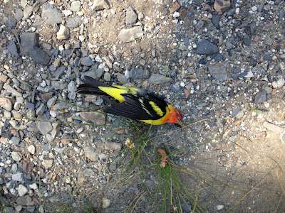
We made it back to the truck after the 7 mile hike down and were surprised to find two dead birds on the ground. They looked to be a male and female of the same species, later found to be a Western Tanager. The only conclusion we could come up with was that they were mating in flight and hit my truck window killing them. Not a bad way to go, I guess, if you gotta go.
The only totem description I could find on the Tanager was that it is a sign you should keep a food filled home.


After a check of the truck for marmots or marmot damage, and a quick stop at the ranger's station we were off, back down the winding road.


We spent the night at a hotel in Exeter; the town that time forgot.
We ate pizza and ice cream, watched movies and took a long hot bath. All hikes should end this way.
Sorry, no pix of that part of the adventure.
The next day we took off to do the long drive home. We had a full day so we decided to take the scenic route and check out some other parts of Sequoia National Forest.


Off the General's Hwy, there is a dirt road leading to Dome Rock. It is popular with rock climbers.
We cruised around and surveyed the area. In the distance you could see Mount Whitney.


Whitney?


We drove on, and had lunch at the Trail of 100 Giants.
This is a grove of some of the largest Sequoia trees I have ever seen! They are amazing beings and too magnificent to capture on film. I suggest everyone take some time to go see them, they'll blow your mind!


Rancher's in the past used to secure their goose flocks in this tree at night to keep them safe from predators.


As we walked the grove we happened upon a Squirrel who was not taking no for an answer. Squirrel rape is quite a sight to behold. Sheesh, no means no dude.


The trees start as independent saplings but later grow into each other to increase their chances of survival.

They have such a shallow root system it is amazing they stand so tall!


Is that a stick that chipmunk is sitting on? Or he is really happy to seem me. :-)

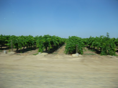
The river was very, very low for this time of year. I fear we are entering a drought summer.


After the bridge we drove through Kern Canyon and out to Bakersfield where we caught the 99 homeward bound. It was a wonderful trip and I will be forever changed by it. I am intrigued and humbled by the
'big-boy' mountains of the Sierra Nevada and cannot wait to return.
This is the GPS track of our trip.
6,255 feet of elevation gain, 22 miles and a high elevation of 11,902.

Nice write up! So, no marmot damage to your vehicle? Do lots of people park by the ranger station with no tarp or chicken wire protection? What about at Cold Springs campground? Sorry for all the questions, I'm looking to do a day hike in that area next week.
ReplyDeleteWe did not tarp, chicken wire or leave the hood open at the ranger station parking lot or the Cold Springs campground. None of the cars parked at the ranger station were tarped or open. We did turn the key over to check the electrical and inspected the engine and under carriage with a flash light when we got back before actually starting the truck. All of the cars at the other trail heads were open or tarped which didn't seem to be doing much good. We passed one car with the hood open and a marmot was sitting on top of the engine happily tinkering away. I tried to chase him away from the car but he went down into the undercarriage. It is worth the extra mile hike to not have to call a tow in my opinion. The ranger gives you a survey to fill out about marmot vehicle damage at the end of your trip and I imagine this is were they get the statistics to back up their parking recommendations. Have a safe trip and thank you so much for reading!!
Delete